
Turn a Delano Address into an APN
A useful Delano street directory trail moves from a physical address to a parcel, then from the parcel to named records. The public assessor route can identify an APN or ATN, but its consumer result suppresses owner names. GIS supplies geometry and map context. The recorder supplies indexed parties. Historical books and newspapers add dated household evidence.
- Enter the situs address in Kern Property Search. Save the APN or ATN, and note whether the address uses a directional, suffix, or unit form.
- Open the same APN or address in Kern GIS. Keep the selected parcel visible while checking adjoining polygons, map-book areas, easements, and legal lot lines.
- Use the parcel identity to orient the deed search. The recorder index is organized by grantor and grantee, not as a single address file.
- Use voter information only through California’s permitted channel. A street-organized walking file is not a public name search.
- For an older household, ask Beale Local History Room staff for the relevant telephone book, newspaper microfilm, vertical file, or yearbook before assuming a modern record will answer the question.
This address method keeps address, parcel, party, and occupant evidence separate. A hit is a lead until the date and record type fit the question.
Delano Property Search by Address
The Kern assessor application is the first practical tool for a Delano by-address search. It is free and CAPTCHA-gated. Search fields load after the security code is accepted. APN, ATN, and property address are alternatives, so a researcher can begin with the clue in hand rather than a name that the public system does not accept.
| Field | Type | Required | Format notes |
|---|---|---|---|
| Security code | CAPTCHA text | Yes | Must pass before the search form is available. |
| Assessor Parcel Number | Text | Alternative | 8 or 9 digits; dashes are optional. |
| Assessor Tax Number | Text | Alternative | 10 or 11 digits; dashes are optional. |
| Property Address | Text | Alternative | Street name with optional number; omit street type, city, and ZIP. Prefix match, first 100 results. |
| Search or Reset | Button | Not applicable | Runs the query or clears it. |
The address form is not an owner-name directory. It is a way to get a stable parcel key. If the result does not fit, test a street spelling without the type, a directional variation, or a neighboring parcel. Keep the original address string because later legal descriptions may use a tract, lot, and block rather than the postal form.
Read Delano Street Parcels in GIS
Kern GIS lets a street-by-street researcher zoom to a parcel, select it, inspect a pop-up, and click adjoining polygons. The layer list, identify or select tools, navigation, and measurement tools provide context for the block. GIS data includes parcel and map-book information, tax-rate areas, public easements, legal lot lines, section lines, and transportation or canal centerlines. It also carries warnings: ancillary layers may be incomplete, and a preliminary edition can contain interim ownership, valuation, or boundary inconsistencies.
Use the selected parcel as an anchor, not as a complete record. The Kern GIS data page identifies APN, owner or assessee name, use codes, and assessed values as dataset attributes, but the consumer property viewer may expose fewer fields. Nearly 17,000 hardcopy assessor map sheets remain official. The 2025 Final Edition represents the July 1 roll close, while preliminary data may be newer but less settled.
| Parcel | A mapped tax and land unit identified by an APN. It may differ from a building, household, or mailing account. |
|---|---|
| Situs address | The physical location of the parcel. It is not the same as an owner’s tax mailing address. |
| Plat | A recorded map or subdivision depiction that helps connect lots, blocks, and legal lines. |
| Criss-cross directory | A reverse directory organized by street or address when a particular volume includes that section. |
Note: A convenient map layer can orient a Delano parcel search, but the hardcopy assessor map controls when geometry conflicts.
Delano Records Searchable by Street
Several Kern and Delano record sets can be keyed to an address, but each answers a narrower question. The coverage table below is the working spine for a Delano street directory because it shows what can be joined and what must remain separate.
| Record set | Keeper | Street evidence | Access |
|---|---|---|---|
| Assessment route | Kern Assessor | Address to APN or ATN; public owner display is suppressed | CAPTCHA search and counter channels |
| GIS parcel map | Kern Assessor GIS | Adjacent parcels, map context, easements, lot lines | Free viewer; hardcopy official |
| Deeds, liens, and plats | Kern Recorder | Indexed parties, dates, instruments, legal descriptions | Online party search, kiosk, or counter |
| Voter walking file | Kern Elections | Street-organized registrants when a permitted file is issued | Application, certification, and fee |
| Permits and planning files | City of Delano | Applicants, project address, APN, and chronology | Targeted request; public portal not verified |
| Telephone or reverse directory | Beale Local History Room | Dated subscriber or household address when covered | Room use; reverse section must be checked |
The APN can link the assessor route to GIS and a legal description. A street name can help find a permit or historical listing. A party name can drive the recorder index. That chain is more reliable than assuming that one street string produces every person connected to the block.
Delano Street Mailing Limits
Kern’s records distinguish situs from mailing address. Situs is the physical parcel. Mailing is where tax correspondence goes. A tax mailing address may be elsewhere, may be a business address, and does not identify the person present at the Delano property. The public assessor interface also does not make an owner-name search available, so the address record cannot claim to show every owner from a web result.
For an address that has changed form, use the APN, legal description, subdivision, lot and block, and recorded instrument number as bridges. Research did not locate an authoritative Delano street-renumbering chronology. Test directional forms and old subdivision descriptions, but label them as search variants rather than local history facts. A parcel split or merger can also change the APN while the street view looks familiar.
Address rule. A tax mailing address can locate an owner’s correspondence, while the situs address locates the land. Neither one is proof of current occupancy.
Trace Delano Street Deeds
The recorder’s grantor and grantee index is the strongest named-party trail on a Delano street. A grantor transfers an interest. A grantee receives it. Start with a known deed, write down the document number, recording date, instrument type, parties, and legal description, then search the earlier party as a grantee. Repeat only when the legal description still describes the same parcel.
The exact online coverage cutoff was not stated on the official pages inspected. Kern’s recorded-document search guidance says official records are organized by document number and parties, and the county removed online APN searching after December 9, 2024. For older or APN-based work, Hall of Records or Recorder Annex kiosks and counter research remain important. The Kern grantor and grantee search shows the party-centered interface used for this route.
The recorded-document screenshot is linked to the official Kern recorder search. Its value is procedural: it shows why a street directory must move from address to party and document rather than expect a single property file.
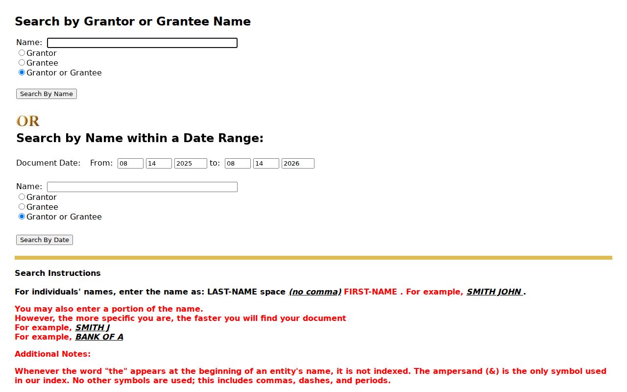
Copies are governed by the county fee schedule. Keep the document number before ordering, and compare the legal description with the GIS parcel. A surname alone is not enough to connect two Delano parcels.
Delano Street Walking File Limits
Kern’s voter application offers a printed walking file organized by street, precinct, or district, but California Elections Code sections 2188 and 2194 limit disclosure and use to permitted election, scholarly, journalistic, political, or governmental purposes. The application asks for identity, requested geography, intended use, identification, and a sworn certification. The county lists a fee for the walking file and separate options for data CDs, alpha indexes, and reports.
California’s My Voter Status tool is private self-service. It asks for first name, last name, date of birth, and sometimes a California driver-license or ID number or the last four digits of a Social Security number. Those identifiers and signatures are confidential. Voting history shows participation, not a ballot choice. A status result can also be inactive or cancelled because of list maintenance, a move, a death notice, or a voter request.
Use the Kern voter-data application for the formal route and the California status form for a person’s own check. Do not turn a restricted walking file into an informal public list.
Delano Street Permit Evidence
Planning entitlements, building permits, code cases, business licenses, council packets, and parcel-related maps can add a date to a street history. They may name an applicant, owner, project, or address. Delano did not surface a verified public permit or code-enforcement database with documented search fields, so the safe route is a targeted request to Development Services or Building by street address and APN.
A California Public Records Act request should identify the record type, address, APN, date range, and department. The city’s public-record route can locate an existing permit or packet, but it does not require staff to build a resident directory or answer an open-ended identity question. Kern County maintains a separate public-records request route for county departments.
When a permit names an applicant, keep that role exact. An applicant is not automatically an owner or occupant. Compare the project chronology with a deed, parcel map, newspaper notice, or directory year before drawing a household conclusion.
Delano Street Telephone Books
Beale Local History Room holds Kern County telephone directories from 1940 and offers Delano newspaper microfilm. A telephone entry can give a subscriber or household name, street address, and number for its edition year. A reverse or criss-cross section may let the researcher work from an address, but the research file does not verify which years include that section or whether every Delano listing appears in each volume.
Call 661-868-0771 before visiting 701 Truxtun Ave. in Bakersfield. Staff can stage requested microfilm or a vertical file. The Delano Branch Library at 925 Tenth Avenue can provide a closer library connection, but the deeper historical collection is at Beale. Use the library’s Local History Room page and its request forms for a specific article, obituary, or directory question.
For an older street directory result, write down the volume date, page, exact spelling, address form, and any abbreviation key. A missing name can mean an unlisted number, a different surname form, a move, or a gap in the shelf. It does not by itself prove that a household was absent from Delano.
Delano Street Maps and Parcels
Kern’s annual GIS archive reaches back to 2004. Final editions capture the roll at close, while preliminary editions can show newer changes with less settled attributes. This gives a previous-owner or street-history researcher a modern digital timeline, but the county still identifies hardcopy maps as official. Use the final edition date in every note so two map snapshots are not mistaken for the same roll.
Adjacent parcel geometry can reveal a block pattern, easement, or subdivision line. It cannot disclose a protected voter, a utility customer, or every household member. A street directory that promises more than the map and recorder can show is overstating the source. Send a specific discrepancy to the custodian with the APN, map edition, and instrument number.
Note: Label GIS work as map context and use the recorder, assessor counter, or official hardcopy map when the parcel boundary matters.
What the Delano Street Directory Misses
No official public roll supplies a complete list of people inside every Delano address. Household members who are not named owners may not appear in parcel records. DMV home-address information is restricted under the federal Driver’s Privacy Protection Act, 18 U.S.C. sections 2721 through 2725. Utility and delivery customer records are not a general public directory. Safe at Home participants use protected registration and substitute-address channels.
Those limits do not make the street directory useless. They define what it can honestly say: the assessor connects an address to a parcel; GIS shows physical context; the recorder connects parties to instruments; a permitted voter file organizes election data; a dated directory or newspaper shows historical publication evidence. The source and date should travel with every conclusion.
Lawful personal use. Delano address records support family history, civic research, and personal safety awareness. Using a street trail to stalk, harass, intimidate, or harm anyone is prohibited and may violate California law.